by Mr Link » September 29, 2026, 11:51 pm
Guest wrote: September 29, 2026, 5:26 pm
Please provide a link to this so-called AIS map. I don't seen any version of a satellite map on the Boatnerd website whatsoever.
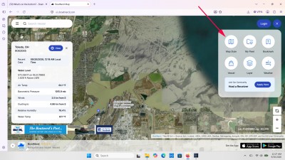
I don't think a link will be useful since Boatnerd's AIS program saves your individual display preferences on your computer or mobile device so any link will look different to each user. So here is a screen shot instead (web version).
To turn on a satellite view, click on the icon with four squares inside of it (next to LOGIN) that is in the upper right corner of the map. That will bring up the menu shown in the screen shot which includes this option for MAP STYLE. That will bring up another menu with various map options, including a SATELITE (sic) view.
As for the lines shown in the water, I agree with Jim B. that it is probably disturbances in the algae bloom that was present when the satellite images were taken. Mapping programs (in this case from ESRI) combine numerous images to cover an area. And they are often taken at different times. In this view, the images for the river upstream of the artificial dredge spoil disposal islands is just showing the typically muddy water of the Maumee River. Along the shore can be seen images taken when there were algae blooms. And the dark color in the upper right (away from shore) is actually an artificial mask (or coloring) added to the images of open water. Most mapping companies add this to reduce confusion caused by reflections, moving vessels, ice or other objects on the water surface.
- Attachments
-
[quote=Guest post_id=275876 time=1790720764]
Please provide a link to this so-called AIS map. I don't seen any version of a satellite map on the Boatnerd website whatsoever.
[/quote]
I don't think a link will be useful since Boatnerd's AIS program saves your individual display preferences on your computer or mobile device so any link will look different to each user. So here is a screen shot instead (web version).
To turn on a satellite view, click on the icon with four squares inside of it (next to LOGIN) that is in the upper right corner of the map. That will bring up the menu shown in the screen shot which includes this option for MAP STYLE. That will bring up another menu with various map options, including a SATELITE (sic) view.
As for the lines shown in the water, I agree with Jim B. that it is probably disturbances in the algae bloom that was present when the satellite images were taken. Mapping programs (in this case from ESRI) combine numerous images to cover an area. And they are often taken at different times. In this view, the images for the river upstream of the artificial dredge spoil disposal islands is just showing the typically muddy water of the Maumee River. Along the shore can be seen images taken when there were algae blooms. And the dark color in the upper right (away from shore) is actually an artificial mask (or coloring) added to the images of open water. Most mapping companies add this to reduce confusion caused by reflections, moving vessels, ice or other objects on the water surface.